While early summer forecasts predicted a brutal 48°C heatwave across the Indian subcontinent, the first half of May 2026 has offered a surprising atmospheric twist. Instead of the expected scorching “Loo” winds, several states are recording maximum temperatures $8^{\circ}\text{C}$ to $13^{\circ}\text{C}$ below the seasonal average.
This climate anomaly isn’t just luck; it is a result of a complex interplay between shifting wind patterns and premature moisture incursions.
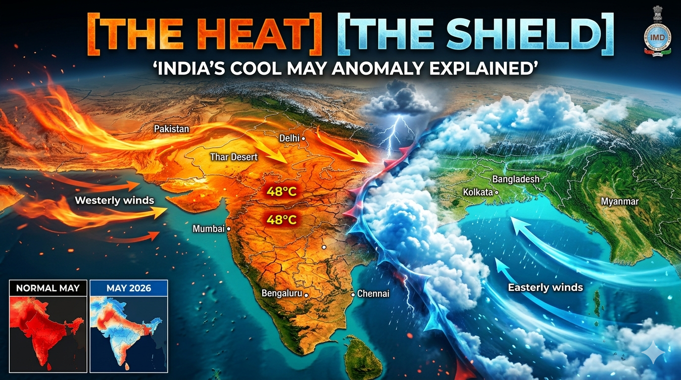
1. The Easterly Wind Intervention
The primary savior this May has been the persistent strength of Easterly winds blowing in from the Bay of Bengal. Typically, May is dominated by dry, hot Westerlies coming from the Thar Desert and Pakistan.
However, a series of low-pressure troughs along the East Coast have pushed moist, cooler air deep into North and Central India. This moisture acts as a thermal shield, preventing the sun from heating the ground to the extreme levels seen in previous years.
2. The Role of the “Western Disturbances”
The Himalayas have seen an unusually high frequency of late-season Western Disturbances (WDs). These extra-tropical storms, originating in the Mediterranean, have brought cloud cover and scattered rainfall across Punjab, Haryana, and Delhi.
- The Result: Cloud cover reflects a significant portion of incoming solar radiation (an effect known as Albedo), keeping the lower atmosphere significantly cooler than a clear-sky day.
3. Early Signals of a Pre-Monsoon Surge
The Indian Meteorological Department (IMD) has noted that the Inter-Tropical Convergence Zone (ITCZ)—the belt of low pressure where the trade winds meet—is migrating northward faster than usual.
- Andaman Arrival: The monsoon is expected to hit the Andaman and Nicobar Islands between May 14 and May 16, nearly a week earlier than the standard schedule.
- The Atmospheric Buffer: This early movement is sucking heat out of the mainland and replacing it with pre-monsoon convective activity (thunderstorms and “Kalbaishakhi” in the East).
4. Is the Relief Permanent?
While the “Cool May” has been a welcome reprieve, meteorologists warn against complacency. The current atmospheric setup is highly fluid.
- The Threat: If the current low-pressure systems dissipate before the actual monsoon onset, a “compressed” heatwave could still occur in late May or early June.
- The Humidity Factor: Even though temperatures are lower, the increased moisture has spiked relative humidity levels. This means the “Real Feel” or Heat Index remains high, as the body’s ability to cool itself through sweat is diminished in humid conditions.
Summary Table: May 2026 Climate Snapshot
| Feature | Typical May Pattern | May 2026 Anomaly |
| Primary Winds | Dry, Hot Westerlies | Moist, Cool Easterlies |
| Sky Condition | Clear, High Radiation | Frequent Cloud Cover |
| Max Temp (North) | $44^{\circ}\text{C} – 47^{\circ}\text{C}$ | $34^{\circ}\text{C} – 38^{\circ}\text{C}$ |
| Monsoon Status | Distant (June 1st Kerala) | Early Surge (Mid-May) |
The Takeaway for India
The 2026 “Cool Anomaly” serves as a reminder of how volatile the Indian summer has become. While the immediate threat of a 48°C spike has subsided, the focus now shifts to the potential for early-season flooding and the impact of high humidity on public health. For now, India breathes a sigh of relief—but the transition to Monsoon 2026 is officially in overdrive.
Based on the article provided above, here are the FAQs designed for the “Featured Snippet” slot on search engines. These address the most common questions users are currently searching for regarding the 2026 climate anomaly.
Frequently Asked Questions: India’s “Cool May” 2026
1. Is the 48°C heatwave still expected in India?
While original forecasts predicted a massive heatwave, the immediate threat has been delayed by a series of Western Disturbances and strong Easterly winds. However, meteorologists warn that if these systems dissipate before the monsoon officially lands, a brief but intense spike in temperature could still occur in late May.
2. Why was Hardoi, Uttar Pradesh, in the news recently?
On May 7, 2026, the Hardoi observatory recorded a maximum temperature of just $26^{\circ}\text{C}$. This marked the coolest May day ever recorded in that location, highlighting the extreme nature of this year’s “Cool May” anomaly.
3. When is the Southwest Monsoon 2026 expected to arrive?
The IMD has forecast a timely to early onset. The monsoon is likely to reach the Andaman Sea and the Andaman and Nicobar Islands between May 14 and May 20, 2026. The official onset over mainland India (Kerala) is still traditionally pegged around June 1, though surges may pull it forward.
4. What is causing the unusual cooling in North India?
The cooling is primarily driven by:
- Moist Easterlies: Winds from the Bay of Bengal bringing moisture and cloud cover.
- Frequent Western Disturbances: Storm systems from the Mediterranean that have triggered rain and hailstorms across the Northwest.
- Reduced Solar Radiation: Persistent cloud cover has increased the Earth’s albedo, reflecting heat away from the surface.
5. Will the “Super El Niño” affect the 2026 Monsoon?
Yes. Despite the current cool weather, climate scientists are monitoring a “Super El Niño” event in the Pacific. This is expected to influence the latter half of the monsoon season, potentially leading to below-normal rainfall (around $92\%$ of the long-period average) and higher-than-average nighttime temperatures.
6. Why does it feel so uncomfortable even if temperatures are lower?
This is due to high Relative Humidity. The cool air blowing in from the sea carries significant moisture. When humidity is high, the body’s sweat cannot evaporate effectively, making the “Real Feel” temperature much higher and more stifling than the actual thermometer reading.
SEO Tips for your Article:
- Slug:
/ - Keywords:.
Super El Niño 2026 impact on Indian climate
This video explains how the developing Super El Niño might override current cool trends and disrupt the upcoming monsoon season.